- A visible lid identifies an access point; the tank, buried route and treatment ground need matched evidence.
- A survey, intended design, completed drawing and current locate answer different questions.
- Assess the full proposed use, temporary access and demand, then confirm the actual local technical and permission requirements.
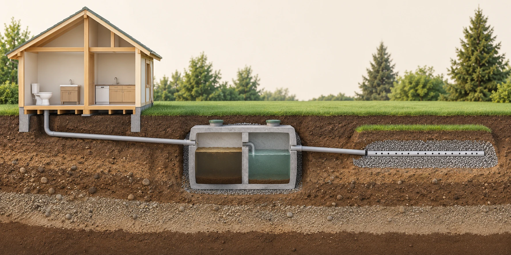
The toilet route connects the house to the tank, and a separate outlet continues toward the receiving soil. Other fixture connections are not exposed.
About this illustration
The arrangement and tank colours are illustrative. The image establishes no actual component location, treatment result, capacity, setback or approved land use. This is a conceptual teaching model, not an assessment of your home.
4 picture lessons appear beside the questions in this guide. Use them to understand the explanation, then consider what it means for your home.
Why is a clear-looking yard not automatically spare building space?
A conventional septic system treats household wastewater in stages. The tank separates solids from liquid; the liquid then travels to a soil-treatment area, often called the septic bed. The ground is doing part of the treatment. A tank lid shows an access point, while much of the system remains buried.
Other system arrangements can include additional treatment or distribution equipment. Ask which arrangement this home actually has and how its components connect. A neat lawn and one visible lid cannot identify the whole route. The separate septic buyer guide covers condition; this guide explains location and future yard use.
Begin with what you want to change: a garage, addition, parking area, pool, trees or drainage. Also mention a proposed suite or other household-use change. A building footprint, vehicle route and change in wastewater demand ask different questions, even when they belong to the same project.
Observe accessible areas from normal safe positions, with permission. Do not dig, probe, open lids or drive equipment across an uncertain system area to find the answer. Give the local qualified provider the records and your proposal so the appropriate investigation can be defined.
Where does wastewater go after it leaves the house?
The toilet route connects the house to the tank, and a separate outlet continues toward the receiving soil. Other fixture connections are not exposed.
Numbers identify the parts explained below.
- House connection
Wastewater leaves the dwelling through the actual connected plumbing. Ask which records describe that route.
- Tank
The tank is one part of the septic system. Its location alone does not locate the receiving area or establish condition.
- Receiving soil
The receiving area has its own location and suitability questions. Clear-looking grass does not reveal those answers.
What does this illustration leave out?
The arrangement and tank colours are illustrative. The image establishes no actual component location, treatment result, capacity, setback or approved land use. Use qualified assessment and the applicable local authority. Do not dig, enter a tank or use this picture as a construction layout.
Which current records and locate findings identify the tank, connections and receiving area?
Explore this with HomeAI ↗Opens an editable question. Nothing is sent until you choose to send it.What does a parcel survey answer, and what does it leave open?
A parcel survey describes the land and features within its stated surveying scope. A septic drawing describes a sewage-system arrangement. Both may be useful, but the word survey does not mean every buried pipe or bed edge was located. Read the actual title, legend, surveyed features, date and qualifications.
Ask the surveyor which locations were measured and which information was copied or supplied by others. If the project depends on a boundary or exact feature position, ask what current evidence is appropriate. A public map screenshot can help you orient yourself without providing the same answer as a scoped survey.
Match the address and legal parcel description across the documents. An older road name, lot change or building label can make a genuine record difficult to match. Keep the mismatch visible until the responsible person clarifies it; do not silently place an uncertain record on today’s lot.
Preserve the complete original sheet, including its scale, north arrow, legend and notes. Cropping or enlarging an image can remove that context. Measuring pixels on a phone photograph does not produce a verified boundary, current component location or project approval. The four-record figure below explains which further document answers each question.
Four records help answer where the system is
Four document types, their location questions and the need to match the parcel, dates, revisions and scope.
Numbers identify the parts explained below.
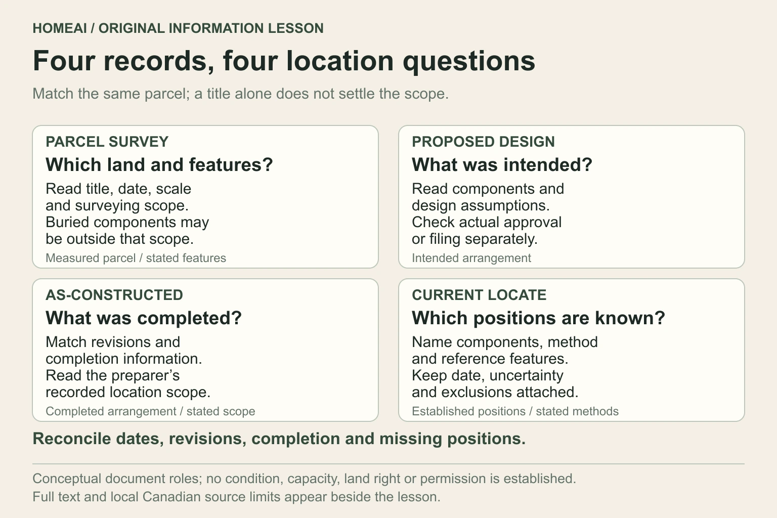
- Parcel survey
Ask which parcel and features were surveyed and whether buried components were within scope.
- Proposed design
Shows the intended arrangement and assumptions; read the actual approval or filing separately.
- As-constructed record
Describes completed placement within its stated scope, with revisions and completion context.
- Current locate
Establishes named positions by stated methods; keep date, reference features and uncertainty.
What does this illustration leave out?
No document, boundary, system location, installation finding or project permission for an actual property is shown. Conceptual document diagram only. Full text below; no drawing accuracy, underground route or authority decision is represented.
Which record answers the location question that this project actually depends on?
Explore this with HomeAI ↗Opens an editable question. Nothing is sent until you choose to send it.Four records help answer where the system is
The documents may use the same parcel, but they answer different location questions. Read each original sheet and its scope, then reconcile the completed system with any current location work.
- Parcel survey
- Which parcel and features were surveyed? Read the title, legal description, date, scale, legend and qualifications. Ask whether buried sewage components were actually within the surveying scope.
- Proposed design
- What was intended under the stated assumptions? Read its actual approval or filing status. A design is not automatically a record of the finished installation.
- As-constructed record
- What completed arrangement does the preparer record? Match the date, revisions and completion or inspection information. Read what the record does and does not locate.
- Current professional locate
- Which specified positions were established, by what methods? Keep reference features, date, uncertainty and exclusions. One located lid does not establish the whole bed boundary.
- Reconciliation
- Match address and legal parcel identity. Preserve disagreements and missing information, then ask the surveyor, onsite specialist and authority which further scope the project needs.
This original figure contains no real document or surveyed site. Location records do not by themselves establish condition, capacity, land rights or project permission. BC, Alberta and RVCA-served Ontario examples remain local; confirm the actual address process.
How do a proposed plan and an as-constructed record differ?
A design plan shows what was intended to be built under its stated assumptions. An as-built or as-constructed drawing records the completed arrangement within its own scope. Read the actual approval or filing status separately. A plan marked approved for construction does not itself record every later construction change.
Look for the preparer, date, revision history and connection to completion or inspection information. Ask which drawing describes the installation that was completed and whether later alterations are recorded. The newest date is a useful clue, but it does not by itself establish what the document verified.
HealthLink BC describes one provincial example: its authorised-person process includes a plan and, after installation, certification, maintenance information and an as-constructed component drawing. That helps explain why intended and completed arrangements need separate records. Confirm the process for the actual address; BC terminology is not a national approval sequence.
Make a short index for design, approval or filing, changes, completion and later work. An installation invoice can name paid work while omitting exact downstream positions. Keep that invoice, but ask for the location and completion records needed rather than expecting a payment record to answer every installation question.
Keep the four location records in their own roles
- Parcel surveyDescribes its surveyed parcel and features. Ask which positions were measured and whether buried components were included.
- Design planDescribes intended components and assumptions. Read its actual approval or filing status separately.
- As-constructed recordDescribes the completed arrangement in its stated scope. Match revisions and completion information.
- Current locateEstablishes named positions by stated methods. Keep date, reference features and uncertainty attached.
What should a current component locate actually establish?
A professional locate is an assignment to establish specified positions. Ask whether it covers the tank, connecting route, distribution equipment, treatment area or another named feature. Finding one lid does not locate every pipe, the bed boundary or a future replacement area. The requested decision should determine the scope.
Ask the provider to record the date, method, reference features, established positions and uncertainties. A mark might identify an access opening rather than a component edge. A drawn line might be approximate. Keep those meanings attached when the information is passed to a surveyor, designer or contractor.
A locate answers its stated location question; condition and capacity may require different assessment. A confidently drawn route does not prove sound pipes, suitable loading or enough treatment capacity for changed household use. Ask which separate questions remain after the location work and who should answer them.
Other utility-locating requirements are separate too. Neither a septic sketch nor this guide authorizes excavation or component access. Tanks and pits can contain dangerous atmospheres. Do not open, enter or lean into them, or attempt rescue by entering. Appropriately qualified providers must arrange the necessary permissions and hazard controls.
What if the file is missing or two drawings disagree?
Describe the disagreement plainly: one plan places the bed behind the house, while another drawing shows a different area; or a service note names a location without measurements. Preserve both originals. Ask who made each record, what it describes and whether a revision or later installation change explains the difference.
Find the records custodian for the exact address. Ontario’s septic overview directs readers to the responsible ministry for requirements, while local delivery varies. RVCA states that it manages septic records for systems built from 1977 onward within current Ottawa boundaries and offers a property-specific search route. Confirm that stated coverage fits this property.
A search route is not a promise that every file is complete or answers today’s location question. Record which documents were supplied and which were not. If a requested drawing cannot be found, ask the specialist how to establish the information needed and ask the authority what current documentation or review applies.
Missing papers do not establish an unlawful or failed system. They leave a question to resolve. Keep document retrieval, physical location and condition assessment distinct, so a successful file search is not presented as a successful system inspection. Discuss consequential uncertainty with the appropriate technical and transaction advisors.
How can I describe future use without pretending to design it?
Write what you want the yard to do. A clearly labelled concept drawing can show a desired garage or parking area against known reference features. Identify existing, proposed and unverified information. It is a way to communicate with the professionals, not a sewage design or permission to begin work.
Include the temporary construction route and storage area, as well as the finished project. Ask where vehicles and materials would go and how future servicing would remain accessible. HealthLink BC cautions against vehicles over onsite systems, large trees near them and adding roof or surface water to the system area.
Those interactions explain why the whole project needs assessment. They do not diagnose past damage from a tyre mark or photograph. Give the provider the proposed loading, planting and drainage questions without inventing an exclusion radius or borrowing a setback from another province.
State household-use changes separately: for example, a proposed suite or rooms that could change demand. Ask whether the existing design assumptions still fit that use. The native project-brief figure separates the footprint, temporary access, ongoing service and demand questions; none of its conceptual shapes establishes suitable soil, capacity or approval.
Describe the whole project before placing it
A labelled proposed footprint and access route beside four brief categories: footprint, temporary access, ongoing service, and drainage or demand changes.
Numbers identify the parts explained below.
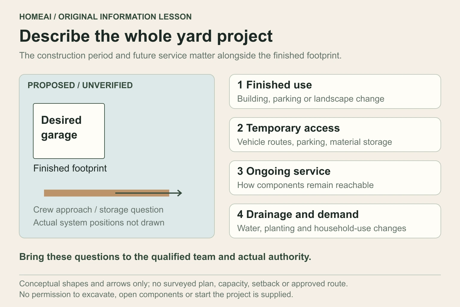
- Finished footprint
Describe the proposed garage, parking or other finished use; mark it proposed and unverified.
- Temporary access
Include crew vehicle approaches, parking and material storage during the work.
- Ongoing service
Ask how the actual system can continue to be reached and serviced after the change.
- Drainage and demand
Name proposed water-routing, planting and household-use changes for specialist assessment.
What does this illustration leave out?
No surveyed layout, identified bed edge, loading capacity, suitable soil, setback, approved route or permission is established. Conceptual communication brief; arrows are questions, not approved routes. This is no design, excavation instruction or property permission.
What would the project change beyond the finished building footprint?
Explore this with HomeAI ↗Opens an editable question. Nothing is sent until you choose to send it.Describe the whole project before placing it
A useful brief tells the professionals what would change during construction and afterward. Show preferences as proposed and keep uncertain system positions explicit.
- Finished footprint
- Name the proposed garage, addition, parking, pool or other use. Identify existing, proposed and unverified information against known reference features.
- Temporary access and storage
- Describe where crew vehicles would approach or park and where materials would be stored. This needs assessment even where the completed building would be elsewhere.
- Ongoing service
- Ask how the actual components would remain reachable for their appropriate servicing arrangement. Do not assume that reaching one lid answers every service-access question.
- Drainage and planting
- State proposed water-routing and planting changes. HealthLink BC cautions against vehicles over onsite systems, large trees nearby and added roof or surface water. Those are reasons to ask about the actual site, not evidence of an existing defect.
- Household demand
- Describe a proposed suite or use change separately so the qualified team can assess the relevant design assumptions.
- Technical and authority questions
- Ask which site-and-system work, surveying, design and local permission process the proposal needs. Keep physical feasibility, land/access rights and permission distinct.
The conceptual footprint and arrows have no survey scale, distance or confirmed component position. They establish no setback, soil suitability, loading capacity, approved vehicle route, sewage design or permission to excavate.
Who assesses the land, the system and permission?
Ask the onsite provider which qualifications and services apply in this jurisdiction. Alberta’s current provincial page identifies contractor certificate-of-competency requirements for obtaining private-sewage design and installation permits. BC has its authorised-person framework. Confirm the actual provider’s qualifications; a familiar credential label does not transfer automatically between provinces.
Tell the provider that the question is a proposed project, not simply whether a tank can be serviced. Ask what the engagement will evaluate, what documents or access it needs and what it excludes. A general condition visit may leave garage feasibility, changed wastewater demand or survey accuracy outside its work.
The technical team may need to reconcile the actual design, located components and relevant land conditions. Ask whether surveying, sewage design or other specialist scope is needed. Have each professional explain their deliverable and its relationship to the other records, rather than treating one service as a complete answer.
Permission is a separate question for the applicable authority. RVCA describes design review, permits and completed-work inspections in its listed Ontario service areas; its FAQs also address renovations and changes of use. Ask which current process applies here. Technical feasibility and permission inform each other, but neither guarantees all future system performance.
Does an unoccupied patch prove there is a future replacement area?
No. Empty-looking ground describes what you can see at the surface. A future treatment location requires assessment of the actual site, system and relevant constraints. A patch that is flat, green or away from a visible lid does not establish suitable ground or an approved replacement option.
Ask whether the original records considered replacement and whether later buildings, landscaping or land changes affect that information. Keep any professional conclusion with its assumptions. A current component locate, a proposed replacement design and an authority decision answer different questions and should remain separately identified.
The absence of a reserve-area label on one old drawing does not establish that replacement is impossible either. Ask what evidence would resolve the question. The cutaway shows why the open surface leaves a land-assessment question; it deliberately identifies no approved reserve, clearance or future design.
If components or access involve another parcel or a shared system, obtain the actual responsibility and access documents. A locate can describe where something is without settling a right to use the land. Legal and transaction advisors interpret the rights and commitments, while the technical team assesses the physical arrangement.
Does open lawn mean a future replacement area?
The left cutaway reveals illustrative system parts. The right-hand lawn has no documented future use or replacement designation in this picture.
Numbers identify the parts explained below.
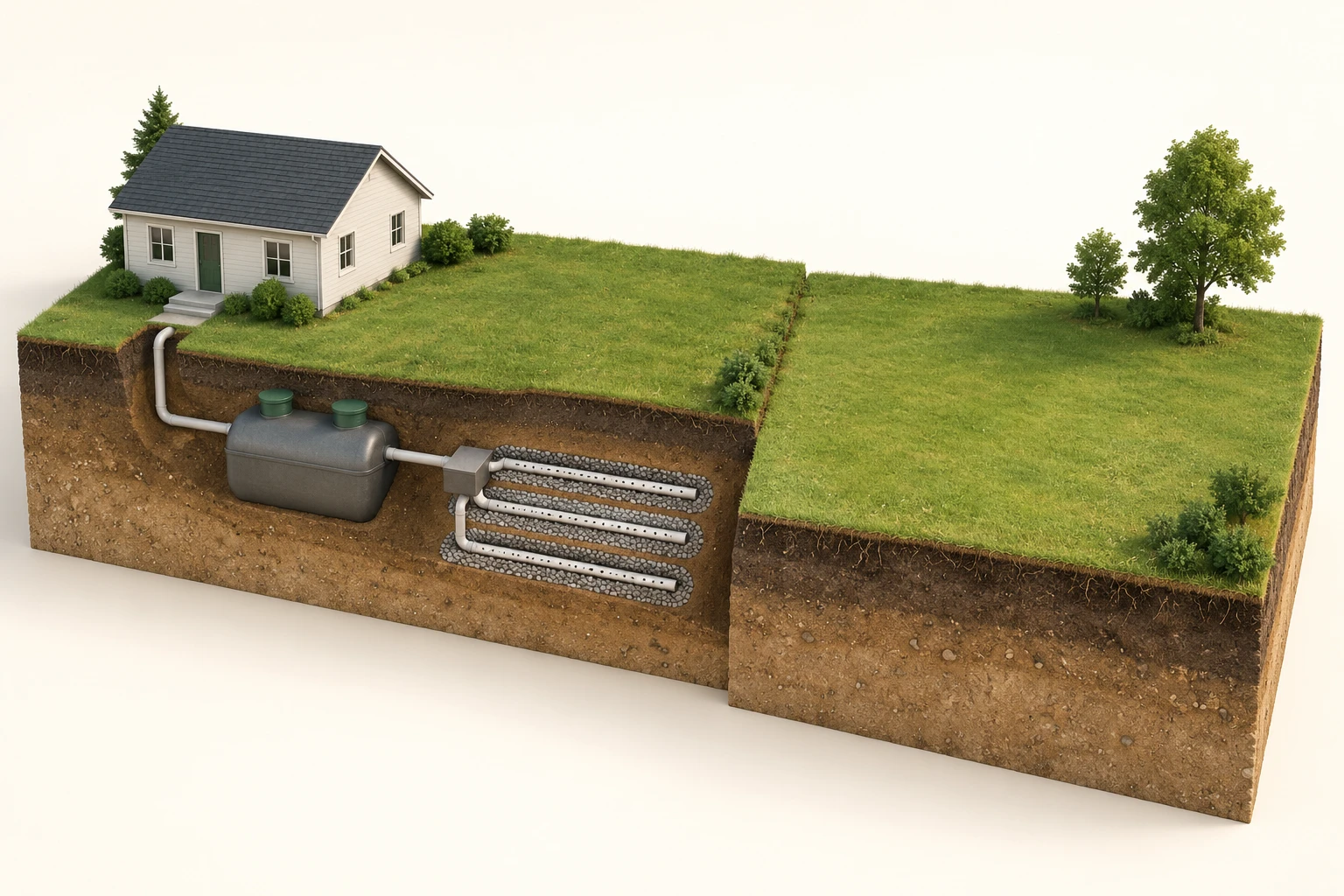
- Existing system
Locate the actual system and keep its current records. The illustration is not a survey of a property.
- Open-looking ground
Grass can look unused while its constraints remain unknown. Ask which investigation addresses the intended use.
- Future-use question
A garage, parking change or replacement proposal needs its own land, system and authority review.
What does this illustration leave out?
Cutaway edges are display boundaries, not parcel boundaries. Open-looking ground proves no available replacement area, suitable soil, setback, capacity or permission. Do not drive, excavate or mark out a replacement bed to test the idea. Discuss the actual proposal with the relevant qualified provider and authority.
What evidence supports the proposed future use or replacement area, and which permission still needs to be obtained?
Explore this with HomeAI ↗Opens an editable question. Nothing is sent until you choose to send it.A position, a project and a right need different answers
- Located componentAnswers where the specified feature is within the locate’s scope; it does not assess every component or future use.
- Project feasibilityAssesses the stated footprint, temporary access, ongoing service, drainage and demand with the relevant site information.
- Applicable permissionThe actual authority confirms its process and required records for this project and address.
- Land and access rightsActual legal documents and advice address responsibility or use across parcels; a physical mark cannot settle those rights.
What does a fictional garage-and-parking case teach?
Fictional buyers Lee and Sam want a garage beside a rural home and temporary parking for the building crew. They receive a parcel survey, an old approved system plan and a pumping receipt. A visible lid appears outside the desired garage footprint. The complete current bed location has not been established.
The survey helps them describe the parcel; the plan describes its stated design; the receipt records its stated service. They keep each document in its own role. None shows that the crew route avoids the whole system or that the proposed household use fits the installation.
They request an as-constructed drawing and later revisions, then give the qualified provider their footprint, crew route, service-access and demand questions. They do not authorize exploratory digging or treat the lid as the system edge. The provider defines the appropriate location and feasibility work for the intended decision.
In this invented case, a locate clarifies a component position but leaves a project question for further design and authority review. Lee and Sam keep that item visible when seeking transaction advice. The example establishes no actual defect, replacement requirement, permitted garage or guaranteed lifespan.
What should a seller or new-build handover preserve?
Keep a matched file connecting the parcel, available design, approval or filing, revisions, completion information, as-constructed drawing, current locate and maintenance plan. State which documents are missing and which details are reported history. A clear file lets the next person distinguish a measured position from an unverified account.
For a new rural home, request completed-system evidence alongside the design used before installation. Ask how the current landscaping and future service access relate to that arrangement. A newly planted lawn cannot supply buried-component positions or prove that later work followed the completed drawing.
After subsequent work, append the provider’s completed scope, relevant authority records and updated drawings where supplied. Preserve earlier versions so changes remain understandable. If a later project was assessed, keep the exact proposal and limitations with the conclusion rather than extending it to every future use.
Your realtor can coordinate authorized records requests and specialist access. If seeking a HAUSE-trained team, confirm actual training, licensing, specialist scope and availability. The surveyor, onsite specialist, authority and transaction advisors answer their respective questions. HomeAI helps explain those roles and organize the file; it cannot approve the yard layout.
Practice the distinction.
The garage, crew route and buried system
Fictional buyers Lee and Sam have a parcel survey, an old approved system plan and a pumping receipt. They want a garage and temporary crew parking, but have no complete current bed-location evidence.
Reported observations
- A visible lid appears outside the desired garage footprint.
- The temporary route and storage area have not been reconciled with the complete system.
- The supplied papers have different purposes and leave later changes or demand questions open.
Compare the explanations
Expand each possibility to see the evidence needed to distinguish it. Similar symptoms can have different mechanisms.
The location file leaves part of the route unanswered
A visible access opening and old design may leave the bed edges or later changes outside the available evidence.
Matched complete records and an appropriately scoped professional locate.
The desired project needs a separate assessment
Knowing a position does not settle construction loading, drainage, demand or permission.
A defined future-use brief, qualified site-and-system scope and applicable authority response.
A useful next question
The buyers request missing completion and revision information and ask the appropriate professionals to assess the complete proposal before relying on that part of the yard.
No actual defect, unlawful installation, replacement requirement, national setback, permitted garage or system lifespan is established.
Know what the words mean.
- Proposed-use overlay
- A clearly labelled communication drawing showing desired work beside known and unverified location information. It supplies no sewage design or project permission.
- Locate scope
- The components, methods and location questions covered by a professional assignment, with its recorded uncertainty and exclusions.
- As-constructed drawing
- A dated record of the completed arrangement within its stated scope; ask how it matches the design, changes and completion information.
Questions to bring
to the conversation.
- Which arrangement does this home have, and do the records match the actual parcel?
- Which locations were surveyed, intended, recorded after construction or established by a current locate?
- Does the proposal include the footprint, temporary route, future servicing, drainage and demand changes?
- Which qualified scope, local authority process and land or access rights need confirmation?
Separate a showing observation, an existing record and a new professional assessment. Unknown means a question remains; it does not automatically mean a defect.
Use the evidence planner ↗Go to the source.
Original HomeAI explanation informed by these public references. Sources support the underlying guidance; they have not reviewed or endorsed HomeAI. Diagrams are conceptual, and calculator outputs depend on your inputs.
Concepts reviewed for this refresh on October 5, 2026. Alberta, Ontario and British Columbia references have distinct jurisdictions. RVCA records and approval services apply to its Ontario service area. A survey, design, completion record and current locate answer different questions; confirm the actual authority and proposal.
Publication & source review
First published .
Sources reviewed .
- HealthLink BC · Maintenance and Operation of Onsite Sewage Systems, file 21
Where this reference applies
Jurisdiction: British Columbia; owner education and BC-specific authorised-person process
Publisher modification date: 2025-03-12
Plan versus as-constructed drawing, maintenance records, land-treatment assessment and protecting the system from vehicle, tree-root and additional surface-water interactions. No BC process is described as Canadian law; no interval, setback or capacity promise is adopted.
- Government of Alberta · Private sewage codes and standards
Where this reference applies
Jurisdiction: Alberta; provincial code and contractor-qualification reference
The page identifies the 2021 standard as current and a current certificate-of-competency context for contractors obtaining private-sewage design and installation permits. The linked standard, numerical design requirements and individual contractor credentials were not assessed here.
- Government of Ontario · Septic systems
Where this reference applies
Jurisdiction: Ontario; rural septic introduction and authority contact
Publisher publication date: 2022-10-14
Publisher modification date: 2024-03-15
Overview and contact route for Ontario Building Code and septic requirements. The linked SepticSmart booklet, separation-distance table and videos are not reviewed through this source object.
- Province of British Columbia · Onsite sewage guidelines and resources
Where this reference applies
Jurisdiction: British Columbia; resource directory for practitioners and owners
Publisher modification date: 2025-10-16
Directory distinguishes practitioner standard-practice, authorised-person, owner-location and flood-response resources. Linked manuals and PDFs are not treated as read or as permission for household locating or excavation.
- Rideau Valley Conservation Authority · Septic record search
Where this reference applies
Jurisdiction: Current City of Ottawa boundaries, Ontario; stated RVCA records coverage from 1977 onward
Public record-search route and parcel-identification documents. No individual property record, guaranteed completeness, fee, turnaround or current-condition conclusion was established.
- Rideau Valley Conservation Authority · Septic FAQs and resources
Where this reference applies
Jurisdiction: Ontario municipalities served through the described conservation-authority agreements; verify the actual address
Design-phase lot, well, dwelling, soil and water-table context; survey supporting documents; application questions for repairs, renovations and changes of use. No numeric trigger, setback, national rule, owner design or tank-access instruction is adopted.
- Rideau Valley Conservation Authority · Septic approvals
Where this reference applies
Jurisdiction: Listed Ontario municipalities, including Ottawa; MVCA/RVCA administration is locally defined
Separate review of designs and plans, permit issuance and inspection of completed work. No individual permit, completed inspection or general Canadian approval process was verified.
- CCOHS · Confined Space: Introduction
Where this reference applies
Jurisdiction: Canada; occupational hazard education, not a legal classification of every household crawlspace
Edition: Fact sheet revised March 12, 2025; page footer modification September 17, 2026
Definition, restricted access, atmospheric, electrical, biological and rescue hazards. No home-entry clearance, household atmospheric test or professional entry procedure is provided.
Have a question about your home?
Start with the symptom, timing and what you have observed.
Ask HomeAI